Route 66 in Pomona CA
Index to this page
About Pomona California
Facts, Trivia and useful information
Elevation: 850 ft (259 m). Population 143,874 (2025).
Time zone: Pacific (MST): UTC minus 8 hours. Summer (DST) PDT (UTC-7).
Pomona is a large city located just to the south of old Route 66 in Los Angeles County in southern California. It is part of the Los Angeles metropolitan area.
The History of the city of Pomona, California
For the early history of the area, read the History of Rancho Cucamonga. Present Pomona was formerly part of the lands owned by the San Gabriel Mission. In 1834 the Mexican Governor Juan Bautista Alvarado seized the land from the Catholic church. In 1837 he granted the land where Pomona is now located to Ygnacio Palomares and to Ricardo Vejar. They established a vast ranch spanning 15,000 acres, it was named "Rancho San José". This covered what is nowadays San Dimas, Azusa, Covina, Walnut, Glendora, La Verne, Claremont and Pomona.
First House "Primera Casa"
Palomares had ranch hands build his home with adobe bricks (sun dried mud and straw bricks), and he named it "Primera Casa" the "First House." He lived there with his wife, Concepción López de Palomares for 17 years. Then they moved to a larger home built 1.2 miles to the northeast. sTheir second home is known as the Ygancio Palomares Adobe and it was located on the trade route linking San Bernardino with Los Angeles. Both historic homes survive to this day and can be visited.
By then, California had become part of the U.S. after Mexico ceded what is now California, Nevada, New Mexico, Utah, Colorado and Arizona to the US after being defeated in the 1846-48 Mexican-American War. California had become a state in 1850.
Vejar sold his part of the ranch in 1863 and after changing hands it was acquired by a developing company to establish a townsite, the Los Angeles Inmigration and Land Co-operative Association.
The name: Pomona
The development company organized a contest to name the new settlement, and it was won by a local named Solomon Gates who suggested Pomona (Aug. 20 1875).
Pomona is the name of the Roman goddess of orchards and gardens. Though in those days there were no orchards or citrus groves in Pomona.
The railroads were built across the area in the 1880s; the town was incorporated it 1888 and became a charter city in 1911.
Pomona College was established in the town in 1887 as a "New England" style University; it was coeducational. However, it soon moved to neighboring Claremont in 1890, which became a "college town"
Citrus ranches gave Pomona the title of "Queen of the Citrus Belt" in the 1920s. But later, after World War II, urban sprawl advanced on the olive groves, orchards and vineyards, as development made space for new residents.
Downtown Pomona was located by the depot of the Southern Pacific Railroad (SP) that linked it with Los Angeles through Walnut and San Gabriel. The use of cars had grown and by 1910 and two main throughfares crossed the town; one ran beside the SP Railroad as a continuation of Valley Blvd. into Riverside and from there to San Bernardino. The other was built to the north of Pomona following the Santa Fe Railroad tracks, from Pasadena in the east, into San Bernardino; it was the National Old Trails (N.O.T.) Highway running along Foothill Blvd.
This N.O.T. highway was incorporated into the alignment of U.S. Highway 66 created in 1926, on the north side of the town, while further south, other U.S. highways were aligned through the central part of Pomona.
The Claremont and La Verne portion of the new highway was completed in 1931 and the whole highway up to San Bernardino became in 1938 the first four-lane divided highway in California.
The 1940s Caltrans road map shows Foothill Blvd. (US 66) running through unincorporated land west of Claremont. At that time the Pomona city limit was further south as the town was centered on US 60, 70 and 99. The built-up area of Pomona didn't reach US 66 in the north as that was an area of open fields.
Route 66 bypassed this area in 1964 when the traffic switched to the freeways, and in 1974 its western terminus was moved to Needles CA eliminating it in most of its Californian segment.

Accommodation in Pomona
You can find your room in Pomona.
> > Book your Hotel in Pomona
More Lodging near Pomona along Route 66
Below you will find a list some of the towns along Route 66 east and west of Pomona; click on any of the links to find your hotel in these towns.
>> Check out the RV campground in Pomona
The Weather in Pomona
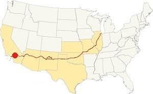
Location of Pomona on Route 66
Pomona has a warm Mediterranean (Continental Mediterranean) climate: semi-arid with hot dry summers and coolish winters.
Pomona has an average of 288 sunny days every year. During fall the Santa Ana wind blows as a hot and dry blast, drying out the area and increasing the risk of wildfires in the foothills of the San Gabriel Mountains.
Early summer is usually overcast ("Mat Gray" and "June Gloom") due to the damp oceanic air flowing in. During winter, the average high is (Jan) 68°F (20°C) and the average low is 39°F (4°C). During summer the average high is 88°F (31°C) and the average low is 61°F (16°C).
The average yearly rainfall is 18.3 in. yearly (465 mm) and the driest period runs from May to September with less than 0.2 in. per month (5 mm).
During winter the peaks of the San Gabriel Mountains receive plent of snow but don't expect snow in Pomona.
Tornado risk
As Pomona is located very far from the Rocky Mountains (western limit for tornadoes), there is no risk of tornadoes in this area.
Tornado Risk: read more about Tornado Risk along Route66.
Map of Route 66 in Pomona
>> Custom map of Route 66 through Pomona.
National Old Trails Highway (N.O.T.) in Pomona
By the 1910s, the use of the automobile had grown considerably but highways were lacking, so the National Old Trails (N.O.T.) Association was formed to promote the construction of a highway to link New York with Los Angeles. Their efforts led to the construction of a dirt trail that was improved over the years, widened and eventually paved. The alignment in this area ran close to the Santa Fe railroad tracks. It was aligned north of the urban area of Pomona along what would later become Foothill Blvd.
Route 66
The N.O.T. highway became the first alignment of U.S. Highway 66 when it was created in 1926. The map below was published one year later (1927) and you can follow Route 66 from Victorville through Cajon, San Bernardino and west into Los Angeles; Pomona is south of the alignment beneath Claremont.

1927 Road map, SW CA
Click on image to enlarge.
Credits

1956 Shell Roadmap, SW CA
Click on image to enlarge.
Credits

Detail 1930 roadmap
Click on image to enlarge.
Full map
The thumbnail map shows the alignment of Route 66 from Victorville to Los Angeles. Pomona is shown in detail.
The map further up shows the same area in 1956; a freeway now links Victorville with Cajon and San Bernardino with Los Angeles. You can see Pomona just south of it, with US 60, 70 and 90 running through it.
In the 1950s, the freeway system in LA would start to divert traffic away from Route 66. By 1964, Route 66 had been replaced by the freeway, and traffic along Foothill Blvd. dwindled. Route 66 remained certified here until 1974, then its western terminus was finally moved to Needles CA.
Route 66 Alignment near Pomona
With maps and full information on the Mother Road.
- Pasadena to Santa Monica (Next)
- Barstow to Pasadena (Pomona's)
- Topock to Barstow (Previous)

Sightseeing in Pomona
Historic Context
Jack DeVere Rittenhouse rode the whole of Route 66 in 1946 and wrote his book: "A Guide Book to Highway 66". He describes this area saying that the towns in this area "... are so close together as to be practically indistinguishable from each other..." yet he did not mention Pomona, as it was located five miles south of the Mother Road, that in those days crosse an area that was mostly orchards and ranches.
What to Do, Places to See
Driving west from Claremont along Foothill Blvd., you enter Pomona when you cross N Towne Ave. This is 4 miles north of the commercial district of Pomona.
Second Shortest Stretch of Route 66
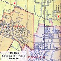
Detail 1956 roadmap of La Verne and Pomona
Click on image to enlarge.
Full map
It is a very short alignment, it ends 200 yards west of Falcon St.; total length: 1.1 miles!
This is the second shortest section of all the towns located along the highway.
- The Shortest segment is the Irwindale CA one, with barely 0.9 miles.
- Third place goes to Berwyn Illinois with 1.5 miles.
Furthermore, west of Williams Ave, the western 0.3 mi stretch along north side of the highway is part of La Verne.
Since the 1940s the city has extended northwards, and by 1956 its northernmost fringe reached Route 66, along roughly 100 yards of roadway on the 300 block of E Foothill Boulevard as you can see in the map (click on it to enlarge it; the red arrows mark Highway 66 and Foothill). Notice that most of the area was unincorporated LA County land (pale yellow).
Development has removed nearly all the old buildings from Route 66, but some classics have survived.
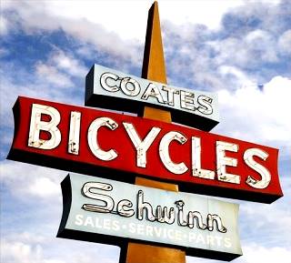
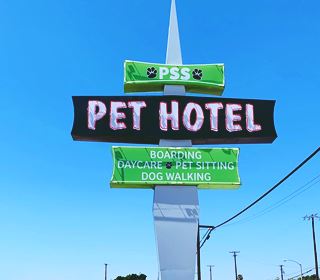
Pet Services (former Coates Cyclery) Vintage sign
Classic Neon Sign
To your left, after the 7-Eleven, at 760 E Foothill Blvd, Pomona is a neon sign that originally belonged to Coates Cyclery, founded by Adair Coates. He began with lawnmower shop in 1934 that sold Schwinn bicyles. Coats sold the business in 1963 to Wes Roth who opened this store on Route 66 as a second outlet. The neon sign was erected with the new building that same year. The last owner was Corey McCroskey who acquired the business in 2002. But he closed the store in 2017 as they couldn't compete with direct sale to the consumers and the internet.
The building is now a Pet Hotel, pet walking and pet sitting business who have updated the neon sign. Below are the former Coates sign, and the current Pet Hotel sign.
Ahead, across the street on the NE corner with Lynoak Dr. there has been a gas station since 1959. Continue west, on the north side of the road is a motel.
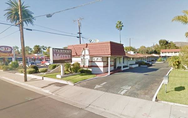
Stardust Motel
At 433 E Foothill Blvd. it appeared in the 1959 telephone directory as the Twilight Motel, in those days it was listed as 433 E Foothill Bl Claremont. Now it is part of Pomona. The motel appears in aerial photographs after 1953. It retained the Twilight name at least until 1969. The building to the right, the Foothill Suites is newer as it appears in the aerial pictures in 1972.
Stardust Motel in Pomona, Route 66:
Retro Route 66 Self Storage
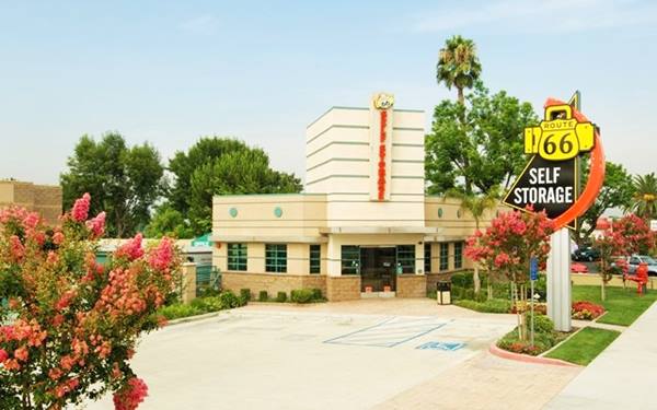
The building across the street, to your left at 450 E foothill has been built in a retro-style, evoking the classic days of the Mother Road. Its neon sign combines a curving red arrow, a black triangle and a padlock shaped like a U.S. 66 shield in a 1950s design, and the main building with its turret has a Streamline Moderne air from the 1940s, enhanced by the vertical sign topped with a U.S. 66 shield. Well done!
Classic Gas Station
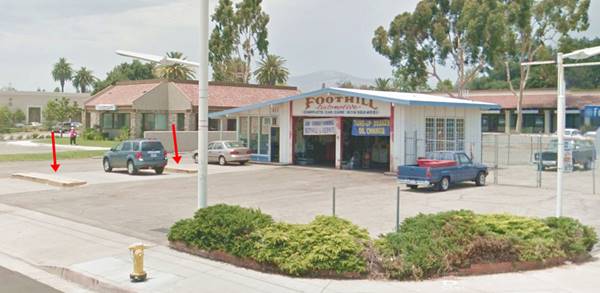
To your right, on the NW corner with Sumner Ave. at 377 E Foothill Blvd, is a former gas station that appears in the aerial photographs after 1966. It was built in a ranch-style typical of the mid-1960s. p>There is what used to be a gas station on the northwest corner of Sumner Ave. and Foothill Blvd. now it is a garage. You can still see the contour of the two concrete islands on which the gas pumps used to be mounted; it had four service lanes. The building has two service ports -garage and repair shop- plus an office. The canopy has been removed. The former pumps' islands are marked with red arrows in the image below:
Foothill Trailer Park
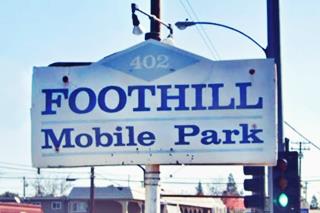
Opposite the gas station at 402 Foothill is a trailer park dating back to the 1950s. Its telephone directory entry mentions "Swimming Pool - Shuffleboard Recreation & Billiard Room... Lawn Bowling..." among its main features. Notice that nowadays it is in Pomona, but in 1959 it was located in "LaVrn."
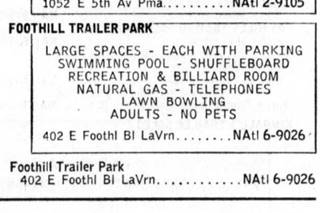
Footill Trailer Park 1959 ad, Route 66, Pomona CA. Source
Californian Trailer Grove
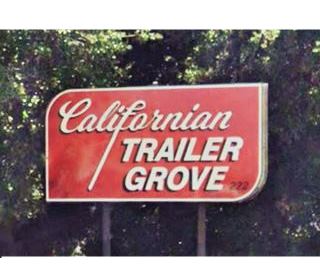
Ahead, to your left at 222 E Foothill Blvd. is a second trailer camp with a vintage sign. It appears in the 1948 aerial photo of this spot, and in the 1959 phone directory under that same name and address. Below is an advertisement published Desert Sun on April 13, 1956, it offered "Heated pool, shuffleboard, club house, large lots with individual orange trees."
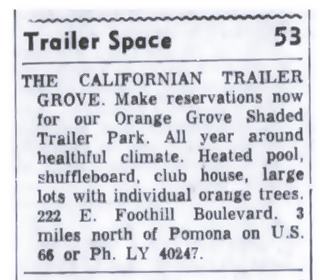
Californian Trailer Grove 1956 ad, Route 66, Pomona CA. Source
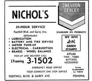
Nichol's Chevron ad, 1959 phone book. Source. Click image to enlarge
The road now curves and takes a SE-NW course. Here, at N. Garey Ave. there were two gas stations listed in the 1959 phone directory, one to your left on the SE corner, at 110 E Foothill, the Garey Center Shell Service; the other across Garey on the SW corner, at 101 W Foothill was Hanson's Flying A Service (now a Chevron). On the NW corner was the now gone Nichol's Chevron (see the 1959 telephone directory ad).
Henry's Drive-In Restaurant (gone)
On the NE corner at 107 E Foothill was the amazing Space Age-styled building that housed Henry's Drive-In Restaurant. It was designed in 1957 by John E. Lautner (1911-1994) who created a vast laminated wood structure that arched over the interior dining area and the outer drive-in section. It formed a shell with an oval shape, with sharp tips. Lautner had also designed the Glendale restaurant in 1947 and the Henry's Famous Rite Spot in Pasadena in 1953.
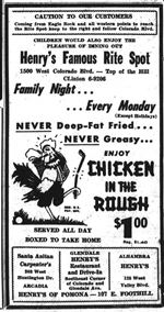
Henry's newspaper ad, 1959. Source. Click image to enlarge
Henry's also had the Carpenter's in Arcadia and another Henry's Drive In in Alhambra. They all featured the "Chicken in the Rough" on their menus, named so because Henry's had once been part of the Oklahoma-based Chicken in the Rough chain. This chain was created in 1936 by Beverly and Rubye Osborne and grew nationwide with 250 restaurants. It's logo was a rooster with tartan trousers, a golf stick in its left foot, a bag of golf clubs on its shoulder, and a golf ball hidden in the grass ("rough" in golfer terminology).
The restaurant closed in 1971 and became "Tiffini's" a night club, but it also closed. The building was torn down in 1986. You can see it in the image below (click on it to enlarge it) that combines a view of the building seen from its western tip and its 1959 aerial photo.
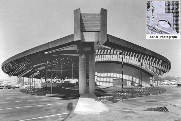
This image looks west, and you can see Nichol's Chevron station (lower left).
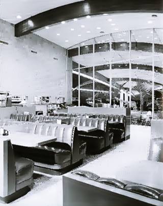
Henry's interior dining area. Source
One block west, was its only competiton in an area that was mostly open countryside in those days, Wilson's, now "La Paloma" a Mexican restaurant; as it is located in La Verne, we describe it in the next leg of our Road Trip.
Motel Foothill
At 141 W Foothill, to your left, was this motel offering "Deluxe Cabins-1 block Wet of Garey," the entry places it in "LaVrn" now this block is in Pomona. The cabins are gone and a hot-dog chain stands on the property.
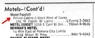
Motel Foothill phone book entry, 1959
Wienerschnitzel
Ahead, to your right, at 175 W Foothill is an original A-frame building with a steep gable roof. It was built in 1966 replacing the Motel Foothill. It was part of the "Der Wienerschnitzel" Hot Dog restaurant chain that opened in 1961; It is the "world's largest hot dog chain." See its St. view.
After crossing the bridge at Thompson Wash, on the corner with Williams Ave., the north side of Foothill is part of neighboring La Verne.
Along the south side, the only structure was a gas station on the SW corner with Falcon St., but it was torn down and now a smog inspection station stands on the property.
This marks the End of this leg of your Route 66 Road Trip across Pomona. Before heading west into La Verne, you can take a short trip to visit some landmarks in the business district of Pomona, four miles south of Foothill Blvd. We describe this side trip in the next section.
Side Trip: Pomona a City Tour
This tour is 9.2 mile-long round trip (map with directions)
Primera Casa de Rancho San Jose
List of Registered Historic Places in Los Angeles County
1569 N. Park Ave., Pomona. 2.4 miles south of Route 66. "La Primera Casa" (Spanish for "The First House") is an adobe building that was the home of Ygnacio Palomares and his wife in 1837. Read more about them and the early history of Pomona further up.
Ygancio Palomares Adobe
Located at 491 E Arrow Hwy, Pomona is the second historic house built by Palomares. It is pictured below in a vintage postcard.
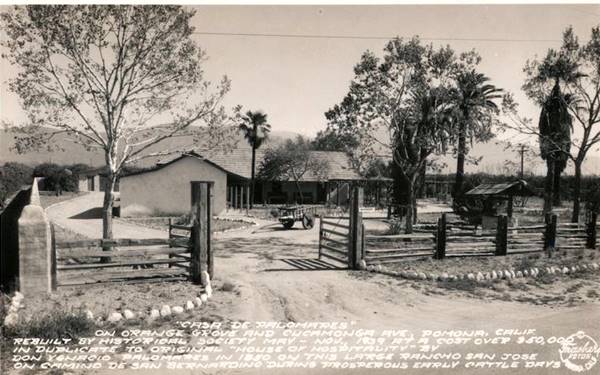
Both adobes are historic sites and operated by the Pomona Historic Society.
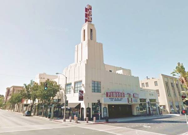
Head south into the downtown district to visit an Art Deco movie theater, the Pomona Fox:
Pomona Fox Theater
Listed on the National Register of Historic Places
Located on the corner of Garey Ave. and Third St., Pomona. The theater opened in 1931 and could seat 1,750 viewers. It was the first air conditioned theater east of Los Angeles. It is an Art Deco building with an 81-foot-tall corner tower that made it the tallest building in the region. It closed in 1976 and bought by the city in 2002 and was restored. It re-opened in 2009, and hosts live music events and private parties.
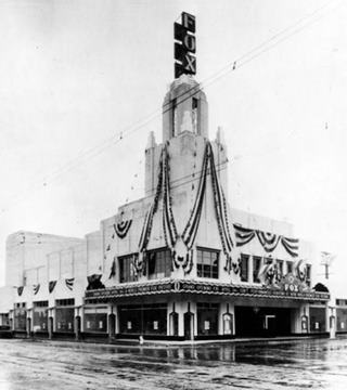
Fox Theater, 1931 inauguration. Source
Continue your Road Trip
The theater marks the end of your downtown tour of Pomona, retrace your steps back to Foothill Blvd. and head west to continue your Route 66 Road Trip and visit the next town along the highway: La Verne.

Sponsored Content
>> Book your Hotel in Santa Monica

Credits
Banner image: Hackberry General Store, Hackberry, Arizona by Perla Eichenblat
Jack DeVere Rittenhouse, (1946). A Guide Book to Highway 66.


